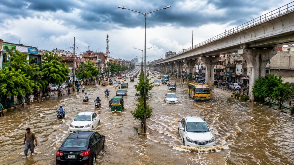
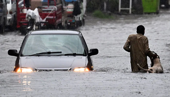
Pakistan’s monsoon season has taken another severe turn as torrential rainfall flooded Islamabad and Rawalpindi, disrupted daily life and pushed the water level of Nullah Lai to dangerous levels.

Pakistan’s monsoon season has taken another severe turn as torrential rainfall flooded Islamabad and Rawalpindi, disrupted daily life and pushed the water level of Nullah Lai to dangerous levels. The latest spell has been particularly intense in Rawalpindi, where rainfall has reportedly broken a 16-year record, with some parts of the city receiving up to 230 millimetres of rain. A similar level of rainfall was last recorded in 2010.
The situation in the twin cities escalated rapidly on September 1, when several hours of intense rainfall overwhelmed drainage systems and flooded low-lying areas. Shamsabad recorded around 201–203 mm, Chaklala around 206 mm, while New Katarian was reported at as much as 230 mm by PDMA.
The rainfall also caused the water level in Leh Nullah, commonly referred to as Nullah Lai, to rise sharply. The Pakistan Meteorological Department reported a level of 29 feet at Kattarian and 23.5 feet at Gawalmandi, triggering evacuation measures in vulnerable areas.
What happened in the twin cities is therefore more than another episode of heavy rain. It is a reminder of how quickly extreme rainfall can overwhelm urban infrastructure and turn a routine monsoon spell into a major emergency.
The most significant development from the latest rainfall has been the record set in Rawalpindi. According to the Rawalpindi Cantonment Board's Chief Water Engineer, the latest rainfall broke a 16-year record, with comparable rainfall last recorded in 2010. PDMA figures showed New Katarian receiving up to 230 mm, while Shamsabad recorded 203 mm and Chaklala 206 mm.

The intensity of the rainfall placed enormous pressure on Rawalpindi’s drainage network, particularly around Nullah Lai and its tributary drains. As water levels increased, water from smaller drains began backing up into surrounding residential areas.
The district administration responded by placing emergency services on alert, deploying evacuation teams and declaring a holiday for educational institutions in Rawalpindi. Residents living near Nullah Lai and in other low-lying areas were advised to move to safer locations as water levels approached critical thresholds.
The record is particularly significant because it places the current rainfall event in the context of Rawalpindi’s recent weather history. A city that has experienced severe monsoon flooding before has now witnessed rainfall on a scale not seen for approximately 16 years.
The impact was not limited to Rawalpindi. Islamabad also experienced intense rainfall, with around 150 mm recorded in E-11 within a short period, according to local authorities. The heavy downpour caused drains to overflow, flooded roads and affected basements and low-lying areas.
Across the twin cities, roads became difficult to navigate as water accumulated rapidly. Residential areas near drainage channels faced particular risks, while traffic was disrupted across several major routes.
The situation around Nullah Lai remained the most closely monitored area. At the height of the rainfall, the water level reached 29 feet at Kattarian, while Gawalmandi reached 23.5 feet. Evacuation measures were subsequently initiated around vulnerable stretches of the drainage channel.
The rapid rise demonstrated how rainfall in the wider catchment area can translate into an immediate urban flood threat in Rawalpindi.
Nullah Lai is one of the most important drainage channels in Rawalpindi. It runs through densely populated parts of the city and carries rainwater from the surrounding catchment areas.
During normal rainfall, the channel helps move excess water through the urban environment. But during extreme rainfall, the amount of water entering the system can increase dramatically within a short period.
This creates a serious risk for communities living close to the nullah and its tributaries. When water levels rise beyond safe limits, surrounding roads, homes and commercial areas can quickly become vulnerable.
The latest event demonstrated this vulnerability once again. Although water levels later began to fall, authorities maintained precautionary measures because the level at Kattarian remained close to the evacuation threshold.
The flooding in Rawalpindi and Islamabad highlights the difference between ordinary monsoon rainfall and an extreme rainfall event.
Urban areas contain large amounts of concrete, asphalt and other surfaces that prevent rainwater from naturally soaking into the ground. When hundreds of millimetres of rain fall over a relatively short period, drainage systems can struggle to remove water quickly enough.
The result can be rapid surface flooding, overflowing drains, submerged roads and water entering homes and businesses.
This is why the recent situation in the twin cities is important beyond the rainfall figures themselves. The record amount of rain exposed the capacity and vulnerability of urban drainage infrastructure under extreme conditions.
The situation in Rawalpindi and Islamabad is part of a much larger national monsoon emergency.
According to NDMA’s latest situation report, between June 26 and September 1, 2026, monsoon-related incidents across Pakistan had resulted in 178 deaths and 504 injuries. More than 1,600 houses had also been damaged, while roads, bridges and livestock suffered significant losses.
Khyber Pakhtunkhwa and Punjab have recorded particularly significant losses, while other regions including Sindh, Balochistan, AJK, Gilgit-Baltistan and Islamabad have also experienced rainfall-related impacts.
The figures demonstrate that the current monsoon is not simply a series of isolated weather events. It is placing sustained pressure on communities and infrastructure across the country.
Extreme rainfall is not new to Pakistan. The country has always experienced powerful monsoon systems, and seasonal rainfall remains essential for agriculture and water resources.
What makes the latest event particularly significant is the combination of extreme rainfall, rapid urbanisation and infrastructure vulnerability.
Rawalpindi’s 16-year rainfall record provides a clear example. A rainfall event of this intensity can overwhelm drainage systems even in a major urban centre. In cities that are expanding rapidly, the challenge becomes even greater as natural drainage areas are replaced by roads and buildings.
The question is therefore not simply how much rain Pakistan receives, but how prepared its cities are to absorb and manage it.
The latest rainfall has also renewed discussions about Pakistan’s vulnerability to climate change.
Pakistan is among the countries highly exposed to climate-related hazards despite contributing a relatively small share of global greenhouse-gas emissions. Changing climate patterns can influence the intensity and behaviour of extreme weather, although individual rainfall events cannot automatically be attributed entirely to climate change.
Flooding is ultimately the result of multiple factors working together. Rainfall intensity, geography, drainage capacity, land use, infrastructure and settlement patterns all determine how destructive an extreme weather event becomes.
For Pakistan, this means climate resilience cannot be separated from urban planning and infrastructure development.
The immediate priority is rescue and relief. In Rawalpindi, Rescue 1122 teams were deployed around Nullah Lai and other vulnerable locations, while authorities continued monitoring water levels and assisting residents. The Pakistan Army, Rangers and other departments were also placed on standby.
But once the immediate emergency ends, another challenge begins.
Flooded roads, damaged homes, disrupted businesses and stressed drainage systems all require recovery. More importantly, authorities need to examine what the latest event reveals about the city’s preparedness for future rainfall.
A record-breaking rainfall event should not only generate emergency responses. It should also generate lessons for future planning.
Pakistan’s growing urban population makes flood resilience increasingly important.
Cities need drainage infrastructure capable of handling more intense rainfall, while vulnerable settlements around natural waterways and drainage channels require stronger protection and better evacuation planning.
Early-warning systems also need to remain a central part of disaster management. The difference between receiving a warning before water levels become dangerous and receiving one after flooding has already begun can determine whether residents have enough time to evacuate safely.
Technology can also play an important role. Weather radar, satellite imagery, hydrological models and real-time river monitoring can help authorities understand where flooding is likely to occur and communicate warnings more effectively.
The record rainfall in Rawalpindi and the flooding across Islamabad and Rawalpindi are a snapshot of a much wider challenge facing Pakistan.
The country needs the monsoon. Its agriculture depends on rainfall, its reservoirs benefit from seasonal water and its ecosystems are shaped by these annual weather patterns.
But extreme rainfall creates a different equation.
When more than 200 mm of rain falls over parts of a major city in a short period, the question becomes whether infrastructure, emergency services and communities can cope with the speed and scale of the water.
Rawalpindi’s latest rainfall record shows that this question is no longer theoretical.
Pakistan’s latest monsoon spell has brought the twin cities of Islamabad and Rawalpindi to the centre of the country’s growing conversation about extreme rainfall and urban flood risk.
Rawalpindi has recorded its heaviest rainfall in approximately 16 years, with some locations receiving up to 230 mm. At the same time, Islamabad experienced intense rainfall that flooded low-lying areas, while Nullah Lai rose to dangerous levels and triggered evacuation measures.
The event is a reminder that Pakistan’s flood challenge is not limited to distant rivers or rural communities. Extreme weather can affect the country’s largest urban centres within hours.
As the water recedes, the bigger question remains: Are Pakistan’s cities prepared for the next record-breaking rainfall event?
The answer will depend not only on better forecasts, but on stronger infrastructure, smarter urban planning, faster early-warning systems and a long-term commitment to climate resilience.
When the rain breaks records, preparedness cannot remain ordinary.
The water level reached approximately 29 feet at Kattarian and 23.5 feet at Gawalmandi, prompting evacuation measures in vulnerable areas.
Nullah Lai is a major drainage channel through Rawalpindi. Heavy rainfall in its catchment can rapidly increase water levels and create flooding risks for nearby communities.
Yes. The Rawalpindi-Islamabad flooding is part of a wider monsoon season that has caused significant casualties and infrastructure damage across Pakistan. NDMA reported 178 deaths and 504 injuries between June 26 and September.
It highlights the increasing importance of urban flood preparedness, stronger drainage infrastructure, accurate early-warning systems and climate-resilient urban planning.